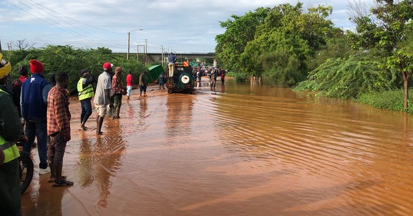
God has blessed Kenya with rains from November 2023 to April 2024. The rainwater has become floods that have caused disaster and deaths. During Diaspora University Town (DUT), Saturday meeting, a proposition was made that the Kenya Floods be considered as a call to Diaspora Kenyans to remit development and contribute toward minimising the dangers of rain storms as well as ensure God's resources are applied to meet the daily needs of people, animals and other living things.
The DUT plan and system is ready for Diaspora Kenyans who would like to remit development. A Diaspora Kenyan joins DUT by committing to invest at least $100 a month through diverse products offered.
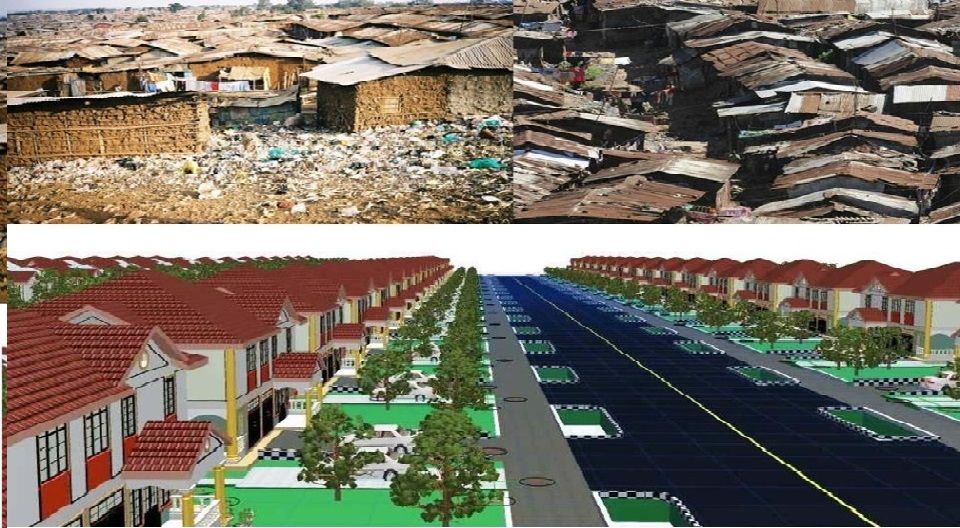
The DUT jobs creation plan will progressively put Kenyans to work and apply the human resource, land resource and other resources in Kenya productively.
Diaspora University project based learning in 10 years after Diaspora University opening will have over 2,000 projects completed by Diaspora University students in the Diaspora University 47 counties project centers.
The 2,000 projects will progress: new town’s development, rainwater management, food production, healthcare standards, waste management, basic education, children’s rights and other plans.

47 COUNTIES ANALYSIS
01 Mombasa
Land, 219.9 sq km about 55,000 acres
Population 1,208,333 people (2019 census.)
Coastline about 30 km with about 10 km beach front.
02 Kwale
Land, 8,267.1 sq km about 2 Million Acres
Population 866,820 people (2019 census.)
Shimba Hills Game Reserve & Mwaluganje Elephant Sanctuary
Coastline about 100 km with about 30 km Beach front.
03 Kilifi
Land, 12,539.7 sq km about 3.15 million acres
Population 1,453,787 people (2019 census.)
Coastline Approximately 150 km with about 60 km beach front; River Athi-Galana.
04 Tana River
Land 37,960.5 km² about 9.6 million acres
Population 316,943 (2019 census.)
Tana River; Ocean, Approx. 50 km, Beach front Approx. 30 km.
005 Lamu
Land, 6,253.3 sq km about 1.56 million acres
Population 143,920 people (2019 census.)
Coastline 200 km with about 50 km Beach front.
006 Taita-Taveta
Land 17,152 sq km (11,000 sq km Tsavo East & West about 2.7 million acres and 6,000 sq km about 1.5 million acres other use)
Population 340,671 people (2019 census.)
Lakes Chala and Jipe
Mzima Springs and Njoro Springs.

007 Garissa
Land 44,736 sq km about 11.3 million acres
Population 841,363 people (2019 census.)
008 Wajir
Land, 56,773.1 sq km about 14.1 million acres
Population 781,263 people. (2019 census.)
009 Mandera
Land 25,939 sq km about 6.5 million acres
Population 867,457 people (2019 census.)
010 Marsabit
Land 70 944.1 sq km about 17.7 million acres
Population 459,785 people (2019 census.)
Game National Park.
011 Isiolo
Land, 25,350.6 km sq about 6.4. million acres
Population 268,002 people (2019 census.)
Ewaso Nyiro River; Buffalo Springs National Park/Reserve, Samburu National Reserve, Shaba National Reserve and Mt Kenya National Park

012 Meru
Land, 7,006.3 sq km about 1.7 million acres
Population 1,545,714 people (2019 census.)
Meru National Park.
013 Tharaka-Nithi
Land 2,564,4 sq km about 660,000 acres
Population approx. 393,177 people (2019 census.)
014 Embu
Land, 2,820.7 sq km about 700,000 acres
Population 608,699 people. (2019 census.)
Mount Kenya slopes.
015 Kitui
Land, 30,429.5 sq km about 7.6 million acres
Population 1,136,187 people (2019 census.)
Tsavo National Park; River Athi.
016 Machakos
Land, 6,042.7 sq km about 1.57 million acres
Population 1,421,932 people (2019 census.)
Athi River.
017 Makueni
Land 8,169.8 sq km about 2.15 million acres
Population 967,653 people (2019 census.)
Tsavo National Park.

018 Nyandarua
Land 3,285 sq km about 820,000 acres
Population 638,289 people. (2019 census.)
019 Nyeri
Land 3,325 sq km about 831,000 acres
Population: 759,164 people (2019 census.)
Mount Kenya and Aberdare hills.
020 Kirinyaga
Land, 1,478.3 sq km about 370,000 acres
Population: 610,411 people (2019 census.)
Mount Kenya.
021 Murang'a
Land 2,524 Km Sq or 631,000 acres
Population 1,056,640. (2019 census.)
022 Kiambu
Land, 2,638.6 sq km about 660,000 acres
Population: 2,417,735 people (2019 census.)
023 Turkana
Land 68,232 sq km about 17 million acres
Population 926,976 people (2019 census.)
Lake Turkana, Oil.
024 West Pokot
Land, 9,123 sq km about 2.3 million acres
Population: 621,241 people. (2019 census.)
025 Samburu
Land 21,065.1 sq km about 5.3 million acres.
Population 310,327 people (2019 census.)
026 Trans-Nzoia
Land 2,496.2 sq km about 625,000 acres
Population 990,341 people. (2019 census.)
River Nzoia.
027 Uasin-Gishu
Land 3,392 sq km about 848,000 acres
Population: 1,163,186 people. (2019 census.)
028 Elgeyo-Marakwet
Land 3,032 sq km about 758,000 acres
Population 454,480 people (2019 census.)
029 Nandi
Land 2,855 sq km about 715,000 acres.
Population: 885,711 people (2019 census.)
Nandi Hills.
030 Baringo
Land 10,976.4 sq km about 2.75 million acres
Population 666,753 people (2019 census.)
Tugen Hills; Lakes Baringo and Bogoria; Diverse Wildlife.
031 Laikipia
Land, 9,532 sq km about 2.4 million acres
Population 518,560 people. (2019 census.)
032 Nakuru
Land 7,462 sq km about 1.9 million acres
Population 2,162,202 people (2019 census.)
Lake Nakuru, Elemetaita, Naivasha; Mount Logonot; Lake Nakuru National Park & Hellsgate National park.
033 Narok
Land 17,960 sq km about 4.5 million acres.
Population 1,157,873 people (2019 census.)
Maasai Mara National Park.
034 Kajiado
Land 21,871 sq km about 5.5 million acres
Population 1,117,840 people (2019 census.)
Lake Magadi; Amboseli National Park.
035 Kericho
Land, 2,436.1 sq km about 620,000 acres
Population 901,777 people. (2019 census.)
036 Bomet
Land 2,630 sq km about 660,000 acres
Population 875,689 people (2019 census.)
037 Kakamega
Land, 3,020 sq km about 755,000 acres
Population 1,867,579 people (2019 census.)
Kakamega Forest.
038 Vihiga
Land 563 sq km about 140,000 acres (2019 census.)
Population 590,013 people.
039 Bungoma
Land 3,023.9 sq km about 755,000 acres
Population 1,670,570 people (2019 census.)
Mountain Elgon; Rivers Nzoia and Malakisi
040 Busia
Land 1,696.3 sq km about 425,000 acres
Population 893,681 people (2019 census.)
041 Siaya
Land 2,529.8 sq km about 630,000 acres
Population 993,183 people. (2019 census.)
Lake Victoria.
042 Kisumu
Land, 2,086.4 sq km about 521,000 acres
Population 1,155,574 people (2019 census.)
Lake Victoria.
043 Homa Bay
Land 3152.5 sq km about 790,000 acres
Population 1,131,950 people (2019 census.)
Lake Victoria
044 Migori
Land 2,613.6 sq km about 650,000 acres.
Population 1,116,436 people. (2019 census.)
Rivers Kuja and Migori, Lake Victoria.
045 Kisii
Land, 1,323 sq km about 330,000 acres
Population 1,266,860 people (2019 census.)
046 Nyamira
Land 897.3 sq km about 225,000 acres.
Population 605,576 people. (2019 census.)
047 Nairobi
Land 703.9 km sq about 175,000 acres
Population 4,397,073 people (2019 census.)
Capital City, National Government Headquarters and Kenya Financial Sector Headquarters
Nairobi National Park